The Great North Wood
7–10 minutes
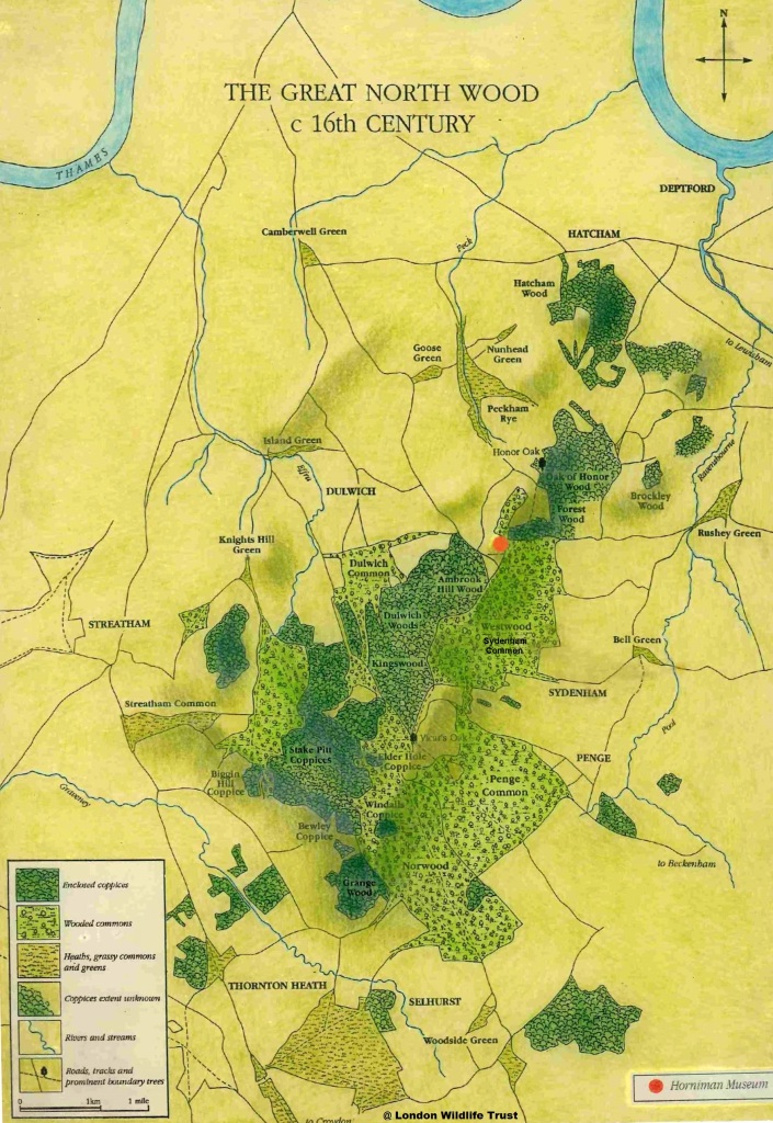
The area were Garthorne Road Nature Reserve is now was wooded and called Forest Wood and a small part of the much larger Great North Wood that stretched from New Cross (Hatcham) to just north of Croydon and from Sydenham to Streatham.
The Great North Wood, known for its open common land and a history of local ownership, was managed for timber, charcoal, and tannin production, which supported shipbuilding and Bermondsey’s leather-making industries using oak bark and firewood. Additionally, gypsies and wood hermits inhabited the wood. However, the Industrial Revolution and the Enclosure Acts of the late 18th Century diminished its economic importance, leading to the partitioning and sale of the land for development.
This large woodland gave rise to the names of local districts such as Norwood, Forest Hill and Penge (edge of wood) amongst others The wood was mainly sessile oak and hornbeam
The Great North Wood, known for its open common land and a history of local ownership, was managed for timber, charcoal, and tannin production, which supported shipbuilding and Bermondsey’s leather-making industries using oak bark and firewood. Additionally, gypsies and wood hermits inhabited the wood. However, the Industrial Revolution and the Enclosure Acts of the late 18th Century diminished its economic importance, leading to the partitioning and sale of the land for development.
Today, the Great North Wood still exists, though in a patchwork of remnants that include small woodlands, parks, cemeteries, sports fields, railway embankments, and private gardens. These scattered pieces form a haven for wildlife within the modern urban landscape. Around twenty sites are left, some of which preserve their status as ancient woodlands. The largest contiguous area, combining Sydenham Hill, Cox’s Walk, and Dulwich Wood, provides a habitat where one can spot woodpeckers and various butterflies, such as the purple hairstreak, amongst the lofty oaks.
The woods are an important natural resource, rich in wildlife and heritage. They serve as an effective ‘green lung,’ providing ecosystem services such as cleaner air for everyone and a tranquil space for relaxation, enjoyment, and mental well-being.
The London Wildlife Trust, a conservation charity, received funding from the Heritage Lottery Fund for the Great North Wood Project. This initiative, ran until December 2022, supporting ‘Friends of’ groups in maintaining numerous sites within the former Great North Wood. These woodlands span across the boroughs of Lewisham, Lambeth, Southwark, and Croydon. The project aims to rehabilitate areas that have been neglected or poorly managed over the years. It also seeks to rekindle and elevate public awareness of these largely forgotten woods, encouraging local residents to discover, enjoy, and appreciate the natural riches right outside their homes.
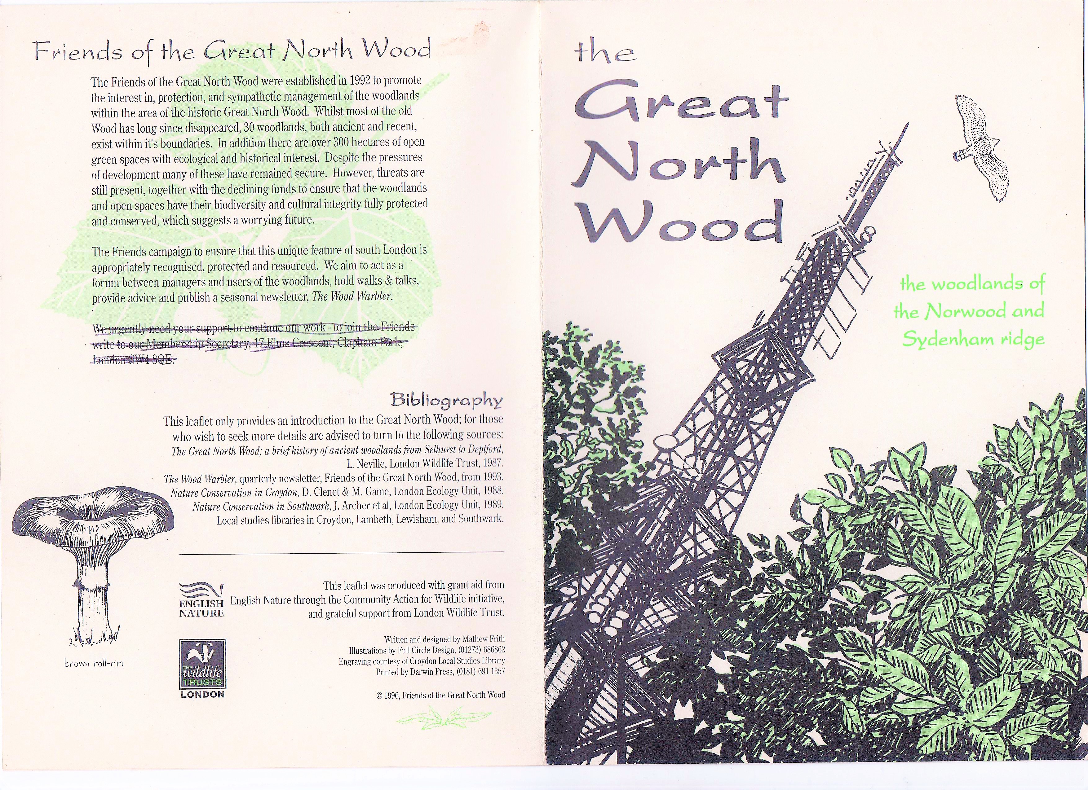
The former Friends of the Great North Wood have created a leaflet detailing the area, complete with a map of existing sites and additional information. It is available for purchase at £1, plus postage. For more details, please contact the Friends of Garthorne Road Nature Reserve via email: garthorne.reserve@gmail.com. The map is also available at the information stall during Open Days. Additional details can be obtained by visiting the London Wildlife Trust website. All proceeds are used to purchase tools and equipment that enhance the biodiversity of the reserve.
A paperback book was published in 2023 about the full history of the Great North Wood ‘ The Wood That Built London’ by Chris Schuler and is available from the Adventure Book Publishers website.

Croydon Canal

The reserve and much of the surrounding land has been subject to much disturbance by public works. Up to the early 1800s with the construction of the Canal the remaining part of Forest Wood stood on the eastern flanks and shows the wood to be L-shaped, bisected by the canal which ran for 9.25 miles from the Grand Surrey Canal at New Cross in south London to West Croydon, via Forest Hill, Sydenham, Penge, South Norwood and terminating at West Croydon.
An authorised by an Act of Parliament in 1801, the canal was originally intended to extend northwards to Rotherhithe, but the simultaneous construction of the Grand Surrey Canal provided a convenient access route and the canal opened on 22nd October 1809.
The canal at West Croydon also linked Merstham and Godstone Iron Railway (itself connected to the Surrey Iron Railway), enabling the canal to be used to transport stone and lime from workings at Merstham. The canal was never extended further south-west, as was initially intended, to reach Epsom. Most of the canal followed the 161 ft contour and was originally planned with two inclined planes but in the end 28 locks was constructed and arranged in two flights with the largest amount of 17 locks between Brockley and Honor Oak and was the highest point on the canal and was 34 feet wide with a maximum depth of 5 feet. It continued snaking around the contour of the land and part of the canal came through the reserve from the north-end before crossing back over to Devonshire Road again following the lay of the land. Extensive earth movements must have created huge amounts of spoil which may account for the uneven topography of the site. Evidence of past building materials can be found and this may be a clue to the path of the canal. The Tithe Maps and the equivalent Apportionment Book show that the surrounding land use at the time was mainly pasture with some arable. The may have affected the site when the woodland was cleared.
To keep the canal supplied with water reservoirs constructed at Forest Hill (Sainsbury’s car park) and Sydenham (Albion Villas Millennium Green), with another at South Norwood which still exists as South Norwood Lake in a public park.

There is still parts of the canal still exists today at Darces Wood Nature Reserve between Forest Hill and Sydenham stations and at Betts Park in Anerley. The canal company charged a toll for goods traveling along the route such as stone, timber, coals, at 3d (55p) per ton per mile while lime. chalk, marl & dung was 1.5d (82½p) per ton per mile. The canal was a failure due to many factors from the banks falling in at Forest Hill and leaking canal bed as well the lack of financial returns and and it closed in August 1836. It was the first canal to be formally abandoned by an Act of Parliament.
More information about this can be found on Diamond Geezers blog. More images of the old Croydon Canal can be found on Steve Grindlay’s Flickr page.
Railway
In 1834 Joseph Gibbs, engineer to the proposed London and Croydon Railway (L&CR) done a survey for a route between London and Croydon and the canal was purchased by the railway company in July 1836 for £40,250 plus one shilling. When constructing the railway it did not completely follow the old canal route leaving parts of it isolated such as at Dacres Wood Nature Reserve and Betts Park in Anerley the cuttings was direct, broad deep, cuttings where it crossed level ground. Extensive earth movements must have created huge amounts of spoil which may account for the uneven topography of the site.
In August 1844 a further Act authorised the railway company to widen its track to four lines and to work one of them on an atmospheric principle. This involved the laying of a large pipe, with a continuous slot closed by a leather flap value along the top, between the rails. Between Forest Hill and West Croydon pumping houses was built at Forest Hill, Norwood and Croydon no locomotives were used and was powered by air pressure or vacuum is used to provide power for traction which lasted about a year but due to high cost of operation and maintenance. The present railway route between London Bridge and Crystal Palace (Low level) was electrified in 1928.

World War II (1939-1945)
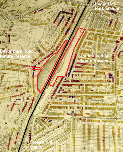
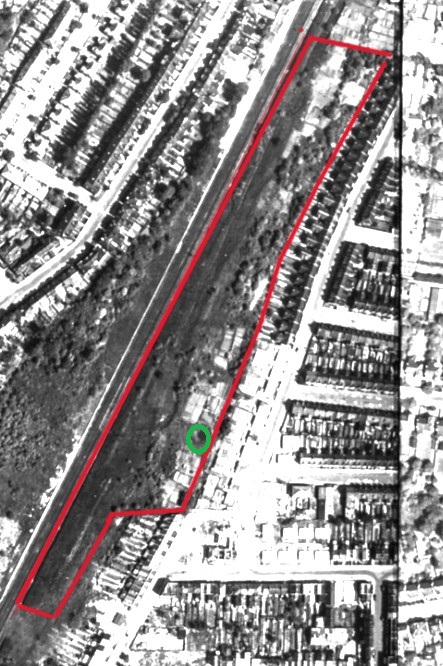
During the Second World War the local area was heavily damaged by enemy bombs and a large amount of the properties was either badly damaged or destroyed along Garthorne Road probably targeting the nearby railway line, numbers 76 – 108 Garthorne Road was destroyed and beyond repair and was demolished and prefabs was built in there place there is a rumour of that several of the bombs may of felled into the reserve behind the houses and that is why some of the area has a couple of large craters one circled in green which according to an local person a pond was also present in the area. Garthorne Road Nature Reserve is outlines in red. Also the site was probably used for allotments along the top of the ridge has their is possible evidence of a few structures remaining and also some fruit trees such as plum and apple trees which is quite old. But have not found any proof yet?. If anyone has evidence please let us know?.

The Green Line Nature’s Railway